Identifying subsidence threats to oil and gas pipelines
For engineers who work on pipelines, there are external threats to be aware of and respond to. Lines that cross through hilly or mountainous terrain are susceptible to land movement, or subsidence.
Studying the terrain and the types of landmass movement is essential for engineers and geologists. It can play a role in determining where a pipeline could or should be built. And knowing about potential subsidence allows engineers, geologists and operators to prepare a response should a landslide or rockfall breach a pipeline.
“Some slope movement can be so slow, sophisticated geotechnical instruments are needed to detect them.”
Different types of landmass movement
According to the United States Geological Society (USGS), landslides occur in all 50 states, depending on certain conditions. However, there are geographical areas where they are more likely to occur. The USGS noted that the mountainous or coastal areas of Washington, Oregon or California are most likely to experience landslides. The Appalachian region in the east is another area that has a high to moderate potential for landslides and slope movement.
There are generally four different types of landslides, noted the USGS. Some happen quickly and seemingly without warning. Others can be so gradual it takes sophisticated geotechnical instrumentation to detect them. Whether landslides happen quickly, or so slowly they are almost imperceptible, they can cause a tremendous amount of damage.
- Falls: These are rather abrupt movements of large objects, such as rocks and boulders, from steep cliffs or slopes.
- Topples: Such landslides are similar to falls. The distinguishing characteristic is that the object falls forward caused by a failure at a pivot point underneath the structure. Weight, gravity or material failure are the most likely causes, though the USGS stated water and its erosive effects also can play a role.
- Lateral spreads: Spreads occur on either flat ground or gentle slopes. They are often triggered by another event, such as an earthquake. The USGS noted that “The failure is caused by liquefaction, the process whereby saturated, loose, cohesionless sediments (usually sands and silts) are transformed from a solid into a liquefied state.” The organization also noted that when coherent material such as rock or soil rests on material that liquefies, it will often fracture, disintegrate or liquefy itself, causing lateral land movement.
- Flows: This is the most complex type of landslide and a flow can be classified in one of five ways:
- Debris flow: This is a rapid mass movement in which a combination of rock, soil, water and other organic matter combine and move downslope.
- Debris avalanche: The same type of material as debris flow. The only difference is the movement is much faster.
- Creep: As the name suggests, creep is so slow, it’s practically unnoticeable. It is the downward movement of soil or rock and it’s caused by shear stress where shear failure causes rapid movement. Creep can be continuous, in such cases where ground material cannot withstand shear stresses. It can also be seasonal, where changes in temperature and other atmospheric conditions cause shear stress.
- Earthflow: The USGS stated earthflows have the shape of the top portion of an hourglass. The material liquefies and forms a bowl at the top and then runs down the slope, narrowing as it flows. Earthflows can happen when the ground becomes saturated, though dry earthflows also happen.
- Mudflow: Like earthflows but they occur when the ground becomes supersaturated. Mudflows move rapidly and contain at least 50 percent of silt, clay and sand, according to the USGS. May often be referred to as mudslides. Heavy rainfalls that oversaturate soil are a primary cause of mudslides.
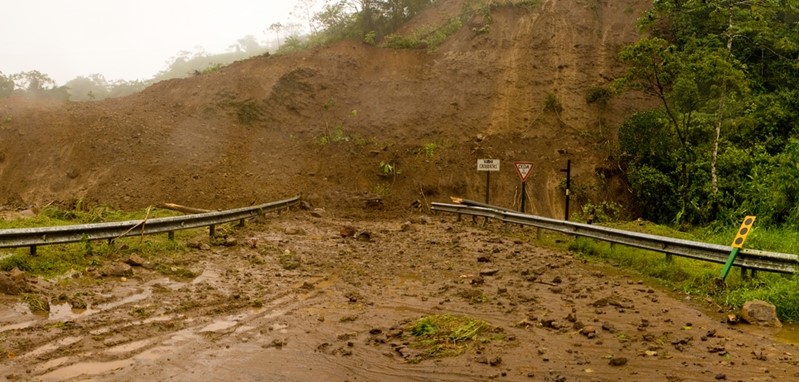
Mudslides can threaten the integrity of oil and gas lines.
Causes
There are a variety of causes or triggers for the aforementioned subsidence/landslides. In a paper for the USGS, authors Gerald F. Wieczorek and James B. Snyder include geological, morphological, physical and human as the four types of triggers.
Geological causes would be the weakening of certain ground materials, which could be caused by such factors as erosion. Morphological causes are more significant earth movements, such as earthquakes or volcanic eruptions.
Physical factors are the most common cause, particularly precipitation. Heavy rainfall may oversaturate and loosen soil. A sudden increase in temperature causing snow to melt quickly may cause oversaturation. An unexpected rise in groundwater may have the same effect, according to Wieczorek and Snyder. The authors wrote that in rocky areas, rainwater and meltwater can penetrate joints and produce hydrostatic pressure. In soil, the authors wrote that “pore-water pressures reduce shear resistance.”
Human causes of landslides include deforestation, mining, irrigation and excavation.
“Physical factors, particularly precipitation, are the most common causes of landslides.”
Methods of measurement
While predicting when a landslide will occur is difficult, different methods that can detect the likelihood of a landslide are available.
Engineers, geologists and technicians are using a variety of geotechnical instrumentation to detect movement. Such instrumentation measures groundwater levels and slope displacement.
Piezometers measure atmospheric and downhole pressure to ultimately determine groundwater levels.
Slope displacement is measured using inclinometers or tiltmeters or a combination of the two. They determine the tilt angle, movement and movement acceleration.
These instruments can be connected to a datalogger through a multiplexer. The multiplexer allows for more readings so more data can be accumulated and interpreted by engineers and geologists. The data can be transmitted through a DSL line or satellite modem so engineers and geologists can assemble data remotely.
A more recently used type of technique is interferometric synthetic aperture radar. This special type of radar, referred to as InSAR, creates a more complete picture that gives an elevation profile. Once the satellite makes a second pass, it can take a second image that engineers and geologists can use to compare to the first image. The differences would then indicate slope movement. One company, Applus RTD Geohazard Management’s team has extensive experience with performing geotechnical instrumentation/monitoring for landmass movement. InSAR and geotechnical instrumentation are some tools used to monitor landmass movement, which reduce the risk to operators, owners and the environment.