Utility Mapping for Risk Reduction in Oil and Gas
The importance of utility mapping cannot be overstated in the Oil and Gas industry. Time critical operations can be delayed during times of emergency if subsurface asset locations are unknown. Maintenance schedules of critical assets can require adjustments due to the configuration of subsurface infrastructure.
Special consideration and concern include the location and identification of ‘Dead legs’. Most sites include ‘dead legs’ where piping was installed for future expansion or where the asset was adjusted after initial installation. ‘Dead legs’ are exposed to the same pressures and corrosive chemicals without the flows that create the equilibrium and consistency of live lines. ‘Dead legs’ can collect sediments or be spots of increased corrosion.
A key component of utility mapping includes the detection and recording of infrastructure that has been abandoned in place. Abandoned in place infrastructure may be properly sealed according to the environmental practices of the day. However, the abandoned lines may not meet modern environmental requirements or safety standards. Abandoned in place lines may predate the current site infrastructure or have been adjusted recently.
New and expanding pipelines can benefit from utility mapping as well as other geophysical surveys, depending on the geologic site concerns. Some of these concerns include critical infrastructure, abandoned or undocumented utilities, existing (or historic) mining activities, karst geology, and steep hills with limited soil cover to name the most common concerns. Surveys that provide information about the subsurface can improve safety and save time and money by eliminating possible surprises.
Asset operators for facilities that contain subsurface pipelines must contend with the potential for damage to these assets at any given time. For a number of reasons, including excavation, heavy-weather events, ground surface slips, environmental investigation or remediation, and new construction, ground must be broken to keep operations moving forward. But when the location and depth of vital underground infrastructure are not properly documented, mapped or transferred onto pertinent parties, crews can easily dig into an unknown line or damage a transmission line while excavating.
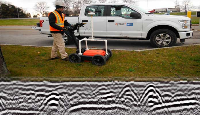
That’s why more and more operators in the oil and gas industry are turning to utility mapping. Utility mapping is a process that combines utility locating techniques of ground penetrating radar (GPR) technology, radiodetection, and electromagnetic induction to locate assets followed by mapping the assets to create digital files. Acoustic pipe locating (APL) is the latest advancement in locating utilities in situations that are otherwise poorly defined. Once the georeferenced information of the delineated lines are recorded and preserved, operators can build 2-D and 3-D maps and various forms of geodatabases to keep on hand. If future construction or excavation is necessary, these maps can be updated and maintained to keep crews from damaging underground assets and ensure full transparency of all infrastructure.
Documentation of the locations of above ground assets can also be missing, inaccurate or incomplete. Laser scanning of above ground piping assets can be used to produce point cloud models of assets. The 3-D mapping and modeling of aboveground piping, valves, support structures and utilities can be instrumental in the planning of maintenance, renovation, expansion and remediation projects. These 3-D models can be integrated with the delineated underground facilities to provide an in-depth comprehensive understanding of the infrastructure at a site.
Non-destructive subsurface exploration on demand
One of the more surprisingly common realities that asset owners and operators of oil and gas facilities face is having to constantly juggle the many forms of data they retrieve. Though sophisticated operations may have established practices and technology for gathering real-time data on assets – such as performance, degradation, life span, location, etc. – others may still rely on paper-based or incomplete processes. Sometimes there may be no standardized procedure for keeping track of these assets and their associated metrics, which makes it far more difficult to keep production moving smoothly or for service providers and regulators to quickly get the information they need before creating reports, recommendations and best practices. In a perfect world, all of this data would be compiled from the time an asset went online.
Today’s subsurface exploration strategies capitalize on non-destructive technology that makes analyzing, cataloging and updating asset information much more seamless. In addition to the benefit of accurate information housed in a single repository, utility mapping also equates to risk reduction on sites. For operators, this means all production assets can be properly maintained and that any physical adjustments to infrastructure can be made in a timely manner following protocol that starts with knowledge of the assets themselves. If, for example, a petroleum pipeline is upgraded from an old low pressure 6 inch line to a new 24 inch pipeline, construction and excavation teams would know exactly how to uproot and uncover vital assets below the surface. This level of refinement translates to faster uptime once production assets are recommissioned, heightened worker safety and peace of mind knowing all measures of security have been taken.
The latest in utility mapping solutions
Updating asset information is one task, but then leveraging that data for greater use is another. That’s where Applus+ RTD’s comprehensive approach to utility mapping services come into play. By utilizing utility mapping and other services such as 3D laser scanning Applus+ RTD can bring clear insight into your subsurface and surface assets in one complete package
Through these methods, operators are able to utilize Applus+ RTD’s data record retention system that can be updated and visualized for future applications. Assets that were once hidden from sight are now located on digital or physical maps using AutoCAD and graphical imaging software, among other technologies.
Bringing infrastructure to the surface, and to life, for engineers, decision-makers and facility operators to see keeps companies well-informed and well-positioned for years of continued success and security.
Learn more about Applus+ RTD’s innovative NDT, Utility Mapping, and GPR services.